
| AN
ARTIST'S VIEWPOINT |
| OVERVIEW by L.H.Barker |
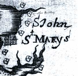
| St. John's Site Museum is a progressive, innovative museum which opened mid-September 2008 in St. Mary's City, MD. The site overview provided by Historic St. Mary's City Foundation describes why it is so important well:
"The St. John's Manor House is one of the most significant archaeological sites in the United States. Built by Mr. John Lewger in 1637-1638, the House was the center of one of the earliest major tobacco plantations in Maryland, and was a building used repeatedly for meetings of Maryland's earliest colonial legislature. It is the place where the first woman attempted to vote, where the first person of African heritage voted in an American legislature, and where one of the earliest major Indian peace treaties was signed. In addition to its historical significance, the site contains some of the best preserved 17th-century architectural remains and archaeological artifacts from English America." |
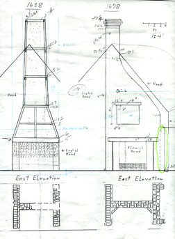 |
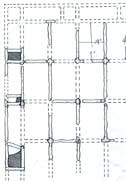
| Elevations and plans of the 1638 and 1678 Chimneys from Historic St. Mary's City. The loose notes and reference lines are the artist's working comments. |
| The exhibit story takes place primarily between 1630s and the 1680s and is about the history of this one property, its owners, how they lived, changes made to the site over various owners and important historical events which took place at the site. St. John's differs from my other Historic St. Mary's City projects, The Chapel and Van Sweringen suites (click to view index), in the following ways: the pieces in this suite of illustrations are painted digitally due to very tight time restrictions, most of the twenty images must precisely line up with other images I have painted or photographs of actual archeological remains because they are in a historical timeline and/or will overlay one another under a lenticular lens (a lens which magnifies different images when viewed from different angles) and B & W technical drawings that describe period building methods are included. The illustrations, along with other educational material, are used on a rail that circles the archeological remains inside the museum facilities. The simple B & W cut-away cartoons are used as "you are here markers" to help orient visitors to where they are in relation to the archeological remains of the building perimeter (below). |
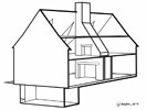 Image 1 (click to view image 1) 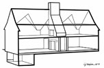 Image 2 (click to view image 2) |
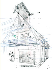
A detailed cut-away interior (click to view image) and the two chimney constructions, 1638 (click to view image) and 1678 (click to view image), are larger on the rail and provide more construction detail. Many of the architectural details in these will be seen in full color in later paintings. The purpose of the detailed cut-away is to educate visitors about space division, number of floors and general architectural finishes. Team discussion includes how much surrounding structure is shown and how much color should be on the chimneys for better comprehension. The chimneys (technically referred to as heating facilities) were very different in materials and construction methods, but built in nearly the same spot. |
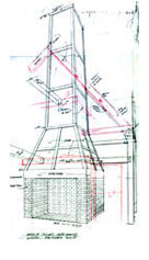 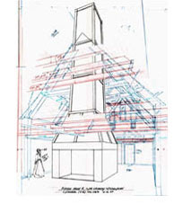 |
| The 1638 chimney rough blocked out manually. Top is a close crop, right includes much more of the building. Rollover the image above to compare the rough with the finished master. Below the 1678 Chimney rough blocked out from the same distance as the 1638 one. Colored pencils are used to record different layers of information by the artist/L.H.Barker. |
 |
| Two free standing buildings, the Quarters (click to view image) and the Kitchen (1655 and 1680 click to view image) are painted to show realistic details and conditions such as tar patch on the clapboard roof and the exterior construction on the period chimneys. The two kitchen perspectives are taken from the same distance and viewing angle to match exactly, so when they are compared in a lenticular viewers can understand the extensive remodeling that occurred between time periods. I construct a hand drawn perspective of the 1655 Kitchen and overlay a second perspective showing how the length of the building was shortened and a new chimney built. The portion of the building which remains intact is the same except that I 'age' some of the materials or render them to appear as recently replaced/repaired material. The Quarters (an unheated store house which later turned into a lodging structure) is constructed and painted in a similar manner. This building is unique for its time, because it lacked foundation sills in its construction; wall studs were placed directly into the ground. |
 |
| Above: Historic St. Mary's City kitchen site plan entitled "1972-2005 Excavations Interim Plan" (highlighting by Barker). This is a typical site plan I am given with archeological notes of dug test holes and found remains. The house footprint with overlapping chimney footprints can be seen in the lower left corner. |
| The Dairy (click to view image) was discovered in 1973 and is not a free-standing structure, but a subterranean addition to the house off what would have been the kitchen/hall room. The perspective is built from an old photo taken when the archeological remains were uncovered; exact angle of view, exact height of view. The stones in the photo become the Dairy floor, exactly. Two illustrations were done for the Dairy: one with the roof on and one x-ray view into the space. |
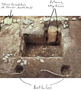 |
| Historic St. Mary's City photograph from the excavated Dairy site, notes the north foundation house wall, the location of the stair risers into the kitchen/hall and the postholes for the structures support. My perspective begins with these architectural elements. |
The three parlor paintings (click to view image) focus on the room at the opposite end of the house from the kitchen/hall. A 1638 view shows the newly constructed room and highlights the period architectural details. This view will be used in contrast with a photograph of the actual archeological remains which now are located inside the museum building. The exact view and eyelevel are matched in my perspective to this photograph. A second illustration is done of this view to show an x-ray view through the parlor floor into the stone cellar. It will help visitors understand the cellar was only under roughly half of this room. The 1642 parlor depicts the same room from a different angle. The scene is a crowded assembly meeting with Governor Leonard Calvert heading the meeting and numerous important historical figures such as John Lewger, Thomas Cornwalleys, Fulk Brent, Thomas Greene, and Mathias deSousa in attendance. It is also important to convey the size of the room (one of the largest interior spaces in Maryland at the time) and show the chimney wall, period furnishings and dress. The most wealthy and powerful men are at or closest to the head table and their richer outfit color and trim reflect their social status. Freemen fill the remaining space. Handsome and unusual leaded glass windows bring light into the room. Finding the best perspective and composition for this illustration took thought and study so the furniture would not obscure the people or room architecture. The parlor served as John Lewger's bedroom, office and space for meetings and is the fanciest room in the house. |
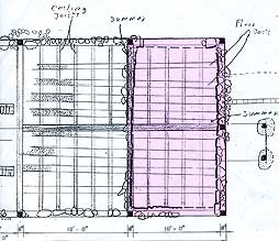 |
| Above: 1640 Parlor floor and ceiling plan provided by Historic St. Mary's City (tone overlay shows the cellar location beneath the parlor). Note the dotted horizontal areas, which represent the mold tracks from floor joists laid in trenches. |
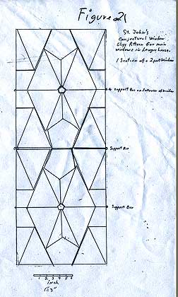 |
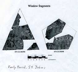
| Above: St. John's conjectural window glass pattern for the Lewger house. The pattern was based on glass window fragments found at the site, below (Historic St. Mary's City). |
 |
| The 1680 parlor depicts the same room as the 1642 parlor, now remodeled by Henry Exon, the innkeeper. It is important to show the chimney/fireplace/west wall, window architectural changes and get across the functional change of the space. When overlaid, the '42 and '80 parlors line up precisely over each other and the digital files for each image have in excess of 200 layers of separate information. The blankets, mattress ticking and table linen are scrutinized for accuracy as well as the period furniture and dress. A period game of chance is put in on the small table at the very end of the painting process. |
  |
| Above left: pattern detail of the Innkeeper's new parlor windows. Right: an outfit showing me the drape, hat and clothing style (both from Historic St. Mary's City). |
| Six aerial landscape 'snapshots' come from a portion of larger very comprehensive works (the Landscape series) which were brought to the rough color study stage and determined to be too detailed and large to reduce well on the display rail. These six large (roughly 22" w x 36"h) landscapes were completed one year later in 2009. The Snapshot and the Landscape series depict St. John's site during 1630-1825 and are taken from the exact same viewing height and angle. The scope of these is quite different from the other illustrations; they encompass a large tract of land and address not only building changes over the period, but vegetation and geographical site characteristics as well. |
| Below: Rollover the Indian Aerial Snapshot to see the relationship between that and the Indian Era Landscape. The Snapshot Series was completed in 2008; the Landscape Series was completed in 2009. Copyrights L.H.Barker. |
 |
| The 1630 Indian Era snapshot illustration (click to view image) and Landscape (click to view image) depict Yaocomico Indians families living, hunting and farming near the site. Areas of focus are the Indian Long House (lifestyle), the slash and burn style agriculture, crops, the proximity to a spring located in the bank, and the virgin forests. Specific trees are selected to show girdling and the slash and burn techniques. |
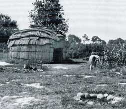
| Below: support material showing a typical longhouse area with the cooking fire and open zone. |
 |
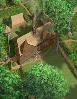
| The Lewger Era Snapshot (click to view image) and Landscape (click to view image) take place in the early 1640s. It is the same precise view as the Indian Landscape. Lewger has built his house, a store house and privy, has a few farm animals and crop fields in this painting. Fences line the property zones to keep wandering wild or loose animals out. A dirt road stretches to the east and a path brings visitors down to or up from the river. The 1642 parlor (described above) articulates some of the house interior. This aerial illustration puts the house into context with the site and when overlaid with the Indian or the Overzee (1656) illustrations, viewers can see how trees mature, die, are cut down, fences and outbuildings built and crops fields changed. |
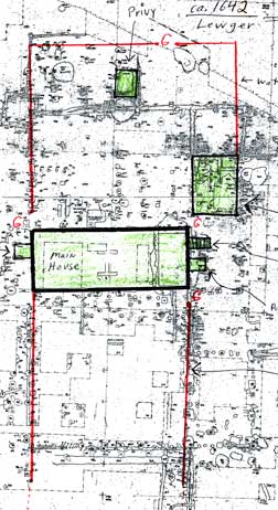 |
| The Lewger site plan gives the artist location of the fences (red) and three buildings (green). A second site plan provides the probable location of crop fields, crop fences and a barn. I combine the two and generate the perspective over which the digital image will be built. |
| Individual trees are selected by the team to carry through the series as visual markers until all are gone in the Farm era rendering. As they age, they grow larger, loose limbs, start to die and then decay. Aligning all the different elements in all six landscapes takes enormous patience and thought and is quite tricky to pull off. Working out a color rough after the perspective is blocked out manually helps a great deal to tweak the composition and determine different vegetation zones. The rough is sent to my team mates with my comments for their feedback and mark up. Ideas are bounced back and forth until we feel we have the best mix of ideas, history and composition. |
 |
| Rollover the image above for a vignette of the Calvert Era Snapshot with the Overzee Era Snapshoot overlaid (L.H.Barker). |
| Simon Overzee's 1656 snapshot (click to view image) rendering and Landscape (click to view image) depict the extensive renovations to the plantation. Among them are converting the store house into a heated kitchen, dismantling the privy, erecting an aisled building (a structure having a rectangular core and aisles running on each long side of building), a square building and replacing a good deal of the fencing. Many of the dead tree stumps in the fields have rotted away leaving primarily the shade trees close to the house. Lewger's English farming is replaced by Chesapeake style planting. The road east becomes more traveled and wider. Midden (trash) areas move with the new fence and gate locations. |
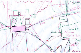 |
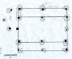
| Above: Historic St. Mary's City schematic site plan for the Lewger (green lines) and Overzee (red line) era. The artist merges the two together to help figure out where paths, midden piles and fences change and the relationship of new buildings to existing ones. The pink tone is the house footprint. Below: the plan of the unusual aisled building. The circles indicate dug test holes by the archeologists. |
 |
| Governor Charles Calvert took over the property from Overzee and the Calvert Snapshot (click to view image) and Calvert Era Landscape (click to view image) take place in 1666. Once again the period illustration records the property changes: a nursery room added to the back of the house and an exterior entrance to the cellar added to the house. A major building called the Quarter is built where a mature tree stood, there is a tenant house (see map below, out of view on the snapshot but on the full sized rendering) and all new fencing. Letters to Calvert's father (Lord Baltimore) tell of experimenting with plow agriculture. The standing structures from the Overzee era are aged and show evidence of repair. The orchard is mature now and some crop fields have turned to barn pasture. |
 |
| A copy of a 1670 Chesapeake Map by Augustine Herrman Map indicates building locations. Historic St. Mary's City. |
Property changes continue in the 1680 Henry Exon snapshot (click to view image) and Innkeeper/Exon Landscape (click to view image). The house goes through major interior changes and exterior repairs with a new fashionable chimney, roof, a porch room over the entry door, the nursery is gone, decorative windows are replaced, the kitchen is shortened and a new chimney built, the aisle and square buildings are gone, midden piles change and fences are new. Surviving trees around the house continue to grow; the Quarter ages, gets repairs and pastures are well developed. The farm era snapshot (click to view image) and landscape (click to view image) interpretive historical paintings fast forward to 1825. Seventeenth century buildings and site characteristics have vanished. Farmers have been working the land for almost a century. A well worn east to west road now cuts through this site. The area is agricultural. The distant scarp has dramatically changed appearance with the event of clear cut logging practices and plowing up or downhill rather than across hill. Evidence of land erosion can be seen particularly along stream/creek/river banks. Once pure waters are now full of silt from the run-off and clogged with swampy growth. The only remaining remnants of the history this land holds are the chimney brick and oyster shell fragments that the plowing brings to the surface. These fragments are the place markers for the people who inhabited this site and what once stood. |
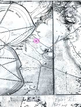 |
| Historic St. Mary's City: a copy of an 1824 map of the region, indicating topography, crop field location and roadways. The pink is the location of St. John's. |
| The St. John's Site Museum represents 4 decades of archaeological research by the Historic St. Mary's City Commission. On May 29, 2009 Historic St. Mary's City Commission won the Maryland Preservation Award for Educational Excellence for the St. John's Site Museum in Historic St. Mary's City, MD |
The Illustrating/visualization Process |
| Use this link to read about the illustrating and painting process. Select the "An Artist's Viewpoint" panel on the right side:Use these links to read more about the illustrating/visualization and painting process in the Chapel, St. John's Museum exhibit, George Washington's Boyhood home/Ferry Farm and Bladensburg suite, . Select the "An Artist's Viewpoint" panel on the right side: |
| The Chapel Suite (hand painted) |
| VanSweringen Suite (hand painted) |
| Ferry Farm Suite (hybrid-hand painted/digitally mastered) |
| Bladensburg Archaeological Project (hand painted) |
~END~ |
| AN ARCHEOLOGIST’S VIEWPOINT |
| OVERVIEW |
| St. John's Museum illustrations team: Roger D. Hill Chief Operating Officer Historic St. Mary's City |
Education: -M.S., Aeronautical Engineering, U.S. Naval -Postgraduate School, 1984 -B.S., Mathematics, U.S. Naval Academy, 1970 -Graduate, U.S. Naval Test Pilot School, 1977 |
Mr. Hill was the Chief Operating Officer at Historic St, Mary's City, a living history site commemorating the founding of the first capital of Maryland. He was responsible for operations; financial management; personnel management; and facilities development, construction, and maintenance. He served in this position from July 2000 to Fall 2008. From January 1995 to July 2000, he was a Program Manager and Director for a high tech, scientific research and development company. He was responsible for marketing, business development, program management, and contract administration for Navy and other Defense related programs. Mr. Hill retired in January 1995 from the Navy after serving 29 years, rising to the rank of Captain. His last tour was as the Commanding Officer of the Naval Air Station Patuxent River, MD. He was the senior executive responsible for overall strategic planning, administration, management, law enforcement, safety, security, and operations of a 7,500-acre facility housing over 10,000 civilian employees and 2,800 military residents. He directly oversaw a workforce of over 1,300 civilian and military personnel, and managed an annual operating budget exceeding $280 million. His responsibilities included operations, maintenance, and repair of over 1,200 buildings and specialized aircraft testing facilities, including two major airports. During his tenure, he managed new construction and capital projects exceeding $350 million. From 1966 - 1995, Mr. Hill served in successively more responsible leadership positions within the Navy as an aircraft carrier aviator, flight instructor, test pilot, program manager, and commanding officer. |
| Henry M Miller Ph.D., Director of Research, Historic St. Mary's City |
| Miller is the Director of Research for Maryland's state museum at Historic St. Mary's City and has over 35 years of archaeological and museum experience. He has directed a wide range of archaeological projects and co-directed the internationally acclaimed Project Lead Coffins. The Chesapeake Bay region is a major focus of his scholarly efforts with emphases upon colonial sites archaeology, human foodways, landscape, environmental change and architecture. Miller received a Ph.D. in Anthropology from Michigan State University with a specialization in historical archaeology and is a member of the Register of Professional Archaeologists. He served as President of the Society for Historical Archaeology (SHA) in 1997, and chaired the SHA's Ethics and Standards Committee and its Curation and Collections Committee. He has also served on the National Historic Landmarks Archaeology Committee. Miller's experience in translating archaeology and history into museum exhibits is extensive and includes the recreation of a 17th-century tobacco plantation, reconstructions of a 1667 tavern, a 1670s storehouse and the massive 1667 Brick Chapel at St. Mary's City. He has worked to design and create exhibits at the 1638 St. John's house, and the 1670s Council Chamber site developed by Dutch settler Garrett Van Sweringen. Besides his St. Mary's City efforts, Miller serves as an archaeological advisor to the Association for the Preservation of Virginia Antiquity's Jamestown Rediscover, and on the museum advisory board of Virginia's Jamestown-Yorktown Foundation. |
| Dorsey Bodeman Director of Public Programs, Historic St. Mary's City |
| Dorsey Bodeman is the director of Public Programs at HSMC. She has been in the museum field for 22 years and has also held positions with Monticello, Jefferson's Poplar Forest, and the Jamestown-Yorktown Foundation. |
| Donald L. Winter Archaeology Laboratory Assistant, Historic St. Mary's City |
| http://www.stmaryscity.org/index.html |
| Les Barker/L.H.Barker Artist/Illustrator/Visualizer http://www.lhbarkerstudio.com (the website you are on now) |
~END~ |
|
| 331
Ridge Rd, Queensbury, NY 12804 Phone: (518) 792-0879 Website (c) L.H.Barker 2004-2015. All rights reserved. |
Interpretive architectural and historical
|
Architectural
Illustration ; www.lhbarkerstudio.com
|
| Website (c) L.H.Barker 2004-2015. All rights reserved. |